How to cite pictures, figures, tables and maps
On this page you can read about how to write references to pictures, photographs, tables and maps using the SLU Harvard reference style. Remember to follow copyright restrictions when you use other people’s illustrations in your work.
When you include an illustration in your work you need to add a figure or table description in addition to the illustration. Figure descriptions are placed below the figure and table descriptions are placed above the table.
Keep in mind:
- The description should include an explanatory text that describes the figure/table. In addition, it should also include information about the origin of the illustration, to inform the reader where the illustration can be found and who the creator is.
- Every illustration needs to be mentioned in the text, to help the reader know when it is relevant to look at it.
- Always add a full reference to the illustration in your text if you did not create it yourself. You can either include the full reference in the figure or table description or add it to the list of figures or list of tables. A third option is to include the complete illustration references in your regular reference list.
If you are unsure of what practice is preferred at your department, please ask your teacher or supervisor.
When you use an illustration that you created yourself you need to make that clear to the reader. You can either add the information to the figure/table description or state on the title page of your work that “the illustrations are created by the author, unless otherwise indicated”.
Copyright
Pictures, figures, tables and maps that you have not created yourself for your text are copyright protected. To be able to use them you need the copyright holder’s permission. Another option is to use a copyright free illustration, where copyright has expired, or use an illustration with a Creative Commons license for example.
Examples for different types of sources
In the examples below, there is a reference to the source in the figure description and a full reference in the reference list or the table of figures.
The figure description should include:
- An explanatory text that describes the figure.
- A reference to the source (creator and year).
Include, if available:
- Creator/organization
- Year
- Title
- What type of illustration it is i.e.[photograph]
- Available: Archive/Database (if the illustration is available in an archive or database)
- Link to the source
- [Date] when the illustration was obtained
The reference is written as follows:
Creator (Year). Title. [type of illustration]. Available: Archive/Database. Link [Date]
The illustration has a Creative Commons license
In figure 1 you can see an example of a photograph licensed with a Creative Commons license that allows you to use it for non-commercial purposes. When an illustration has a CC license you need to add a link to the license in the figure description or where you choose to state the full reference. In this example, the creator is a person.

Figure 1. Mushrooms (ONeal 2009) (CC BY-NC-ND 2.0).
The full reference to figure 1:
ONeal, C. (2009). Mushrooms. [photograph]. https://flic.kr/p/7susWa (CC BY-NC-ND 2.0) [2020-02-13]
The illustration is used with the permission of the creator
In figure 2 you can see an example of a photograph taken by a person, where you have the creator's permission to use it in your text. It must be clear to the reader that you have this permission. You can clarify this in the figure description, in the table of figures, in the reference list or write it on your title page.
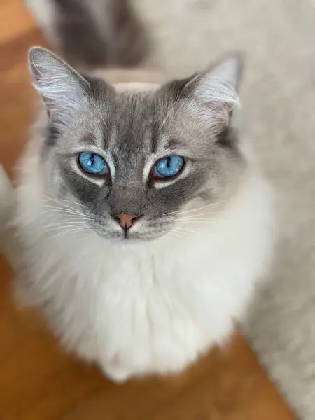
Figure 2. A ragdoll with blue eyes (Persson 2022).
The full reference to figure 2:
Persson, M. (2022). Frasse. [photograph]. https://flic.kr/p/2nnoXci [2022-05-25] Used with the copyright holder’s permission.
When the illustration is from another work you cite that source, as well as the page where the illustration can be found, instead of the illustration directly. The format of the full reference is depending on the type of source. You can read more about references to different sources on this page:
In the examples below, there is a reference to the source in the figure description and a full reference in the reference list or the table of figures.
The figure description should include:
- An explanatory text that describes the figure.
- A reference to the source (creator, year and page number).
The creator of the illustration is the same person as the author of the source
Figure 1 shows how cells divide. The picture is from a book and its creator is the same as the author of the book.

Figure 1: Cell dividing in simple steps (Burkett 1914:10).
You write the full reference based on the source type. In this example, the picture is from a book:
Burkett, C.W. (1914). The Farmer's Veterinarian. New York: Orange Judd Company https://www.gutenberg.org/files/55366/55366-h/55366-h.htm [2022-05-30]
The creator of the illustration is someone other than the author of the source
Figure 2 shows a tree swallow. The picture is from a book and the creator of the picture is someone other than the author of the book. In this case the creator of the picture should be named in the figure description, instead of the author of the book.

Figure 2. Tree swallow (Singer 1977:61).
You write the full reference based on the source type. In this example the picture is from a book where the authors are not the creators of the picture. You write the reference as if it was a book chapter:
Singer, A. (1977). Tree swallow [drawing]. In: Scott, V.E., Evans, K.E., Patton, D.R. & Stone, C.P. (eds) Cavity-Nesting Birds of North American Forests. Washington: Forest Service U.S. Department of Agriculture https://www.gutenberg.org/files/49172/49172-h/49172-h.htm [2022-05-30]
You can create images using tools based on generative artificial intelligence. However, reviewing the rules for using AI within your course and assignment is important to ensure it is allowed.
If you use an image generated with AI, the image description should include a brief description of the image, and within parenthesis:
- the tool used to create the image,
- the prompt used, and
- the year the image was created.
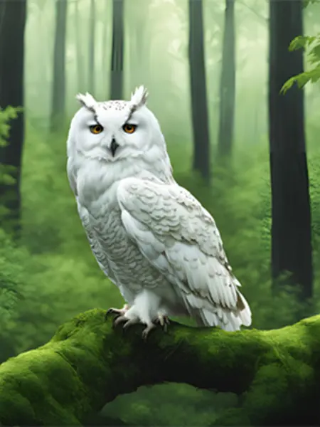
Figure 1. A white owl is perched on a branch. (Image created with Canva from the prompt ”A white owl in a green forest”, 2024).
No full reference to the image is required, as it cannot be recreated or retrieved.
When you use a table in your work, you need to include a table description that explains the content directly above it. The text should also contain a reference to the table to provide context. The reference can for example be written like this:
Usage of water is likely to decrease further (Table 1) in the following years.
If you use someone else’s table, you need to be aware of any copyright restrictions. If you only use the data, but create the table yourself, you only need to cite the source.
In the example below, there is a reference to the source in the table description and a full reference in the reference list or the table of figures.
The table description should include:
- An explanatory text that describes the table.
- A reference to the source (creator, year and page number).
Table 1. Singapore’s domestic household water consumption (Rowe & Hee 2019:59) (CC BY 4.0)
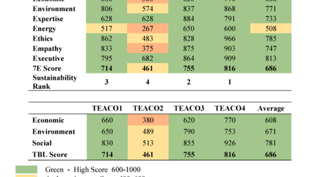
You write the full reference based on the source type. In this example the picture is from a book:
Rowe, P.G. & Hee, L. (2019). A City in Blue and Green : The Singapore Story. Singapore: Springer https://link.springer.com/book/10.1007%2F978-981-13-9597-0 (CC BY 4.0) [2020-03-16]