
A New Mobile Tool for Assisted Citizen Science Monitoring of Rangeland Restoration
A new module in the Regreening App enables restoration practitioners to collect data on rangeland restoration interventions and track their effectiveness over time.
Rangelands cover vast areas of Africa and are central to pastoral livelihoods, biodiversity, and climate resilience. Yet, despite their importance, rangelands have long been undermonitored, leaving major gaps in our understanding of rangeland health dynamics and the effectiveness of restoration activities.
To address this challenge, Restore4More has supported the development of a free mobile-based application module, co-designed with users and developed by our project partners at CIFOR-ICRAF. This tool enables communities and restoration practitioners to systematically record and monitor rangeland restoration activities. The Rangeland Module in the Regreening App is now complete and ready for use. The Regreening App can be freely downloaded from the Google Play Store.
Why monitoring rangeland restoration matters
Restoring degraded rangelands is essential for reversing biodiversity loss, tackling land degradation, improving water availability, and strengthening climate resilience. Without consistent monitoring, it is difficult to know which interventions work where, how rangeland ecosystems respond over time, why some practices succeed while others fail, and how to adapt rangeland restoration and management strategies for better outcomes.
Citizen science provides a powerful and inclusive pathway to fill these gaps, especially when supported by intuitive, accessible digital tools.
A new tool co-developed for rangeland realities
The Regreening App, developed by CIFOR-ICRAF, is an Android mobile application that enables users to collect data on a wide range of land restoration practices, providing evidence to guide restoration efforts while assessing their effectiveness on the ground. Originally designed to collect data on tree planting and Farmer Managed Natural Regeneration practices, the app now expands its functionality with the new Rangeland Module, which supports data collection on other restoration interventions common in rangeland systems.
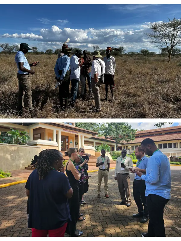
The rangeland module has been co-designed with a broad range of rangeland restoration actors in East Africa, including pastoralist communities, local authorities, NGOs, livestock and rangeland government officers, etc. Through workshops, field testing, and iterative feedback, the module has been tailored to the context of rangelands and the realities of and needs of those working on rangeland restoration on the ground.
The result is an accessible, structured, and scalable tool that enables assisted citizen science restoration monitoring in rangelands, enabling systematic documentation of interventions, tracking changes over time, and strengthening the evidence base for rangeland restoration.
How the Rangeland Module works: Field data collection
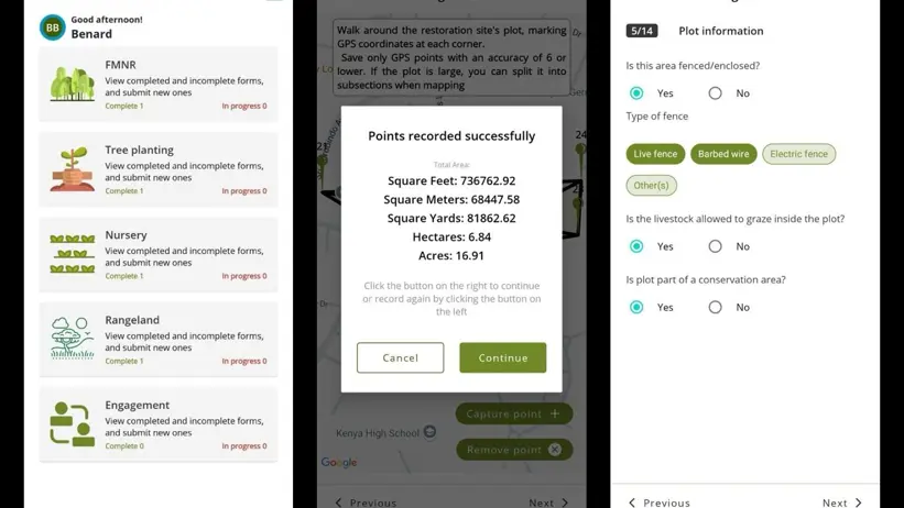
The module provides a structured system for recording, mapping, and monitoring rangeland restoration at the plot or intervention level. It captures information in two main phases: establishment and current status monitoring.
1. Establishment phase - Documenting new interventions
For each restoration site, users can record information such as:
- Intervention type: halfmoons/microcatchments, seeding, erosion control, grazing management, or other practices
- Land ownership
- Measurements of structures such as halfmoons, zaï pits, or terraces
- Herbaceous cover, etc
- Species planted or seeded, including grasses or trees
- Primary reasons for establishing the intervention
- Plot mapping, by walking boundaries and marking GPS points
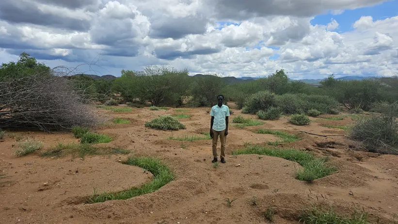
- Initial photos to establish a clear baseline
2. Current status monitoring - Tracking change over time
To track progress and evaluate effectiveness, during revisits, users can document the present condition of the intervention, including:
- The current percentage of herbaceous cover
- Whether the structures remain intact or have been damaged (e.g., swept away by floods)
- Visible signs of soil erosion within the intervention site
- The presence and condition of grasses and trees
- Updated photos to assess changes over time
Types of restoration interventions the Rangeland Module captures
The Rangeland Module supports the documentation of a wide range of restoration interventions commonly implemented in rangeland systems. For each intervention type, the app records detailed information during establishment and revisiting, creating a consistent dataset that helps track changes over time.
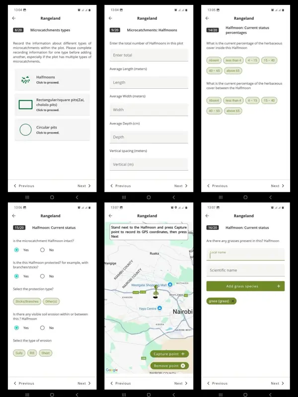
Microcatchments
These structures capture and retain surface runoff, supporting vegetation establishment and reducing erosion. The module allows users to document different types of microcatchments, including halfmoons, rectangular or square pits (e.g., zaï pits, chololo pits), and circular pits.
Information collected includes structure size, spacing between microcatchments, number of units constructed, their condition over time, vegetation cover within and between structures, and signs of erosion.
Seeding
The module also records data on seeding of grasses, forbs or other herbaceous or woody vegetation. Users can document information such as when seeding was done, which species were seeded, the seeding methods used, and vegetation cover recovery over time.
Erosion control measures
The app captures data on a range of erosion control structures, including terraces, check dams, gabions, and different types of contour bunds.
During monitoring, users can record the condition of these structures, visible signs of erosion, and vegetation recovery.
Grazing management
Rangeland health is closely linked to grazing management. The module enables users to document whether plots are fenced or open, the type of grazing management applied, rules or practices for livestock access, land governance arrangements, and observations on pasture conditions.
Other practices
Other rangeland restoration practices in the app include woody encroachment and invasive species control, and farmer- or pastoralist -led managed natural regeneration (FMNR-PMNR).
Mapping and monitoring water points
In rangeland systems, the presence, type, accessibility, and management of water points strongly shape livestock and wildlife movements. These patterns of use, in turn, drive grazing pressure and stocking densities, with significant implications for rangeland health.
The Rangeland Module allows users to map a wide range of water sources across rangeland landscapes, including boreholes, wells, springs, dams, sand dams, water pans, rivers and streams. For each water point, the module captures detailed information such as primary use (livestock and/or widlife, household consumption, irrigation), functionality (operational, partially functional, or non-functional), infrastructure present (pumps, storage tanks, water troughs), seasonal availability (year-round, dry season only, or wet season only), accessibility (distance to communities or grazing areas), potential contamination risks (agricultural runoff, latrines, waste), protection measures (fencing, well covers and sealing systems, community oversight), GPS coordinates and photos for accurate mapping and long-term monitoring.
What happens to the data? From field observations to insights
Data collected through the Rangeland Module does not remain on individual devices. Instead, it is uploaded to the Regreening App Data Reporting System (DRS), an online platform that allows project managers and practitioners to securely access, manage, and interpret their data in Near Real Time (NRT). Through the DRS, users can explore the information gathered in the field, visualize restoration activities across sites, track progress over time, and download datasets for further analysis.
A key strength of the system is that restoration intervention areas are georeferenced. Once the precise boundaries of each intervention area are mapped in the app, these locations can be linked to Earth Observation(EO) data. This enables changes in vegetation, land cover and other indicators of rangeland health to be monitored over time. By comparing restored and unrestored areas, detecting trends, and identifying where restoration is progressing or facing challenges, EO data adds a powerful layer of information that complements field-based monitoring.
Together, the Regreening App, the DRS, and EO create a connected workflow: field data collected through citizen science feeds into a centralized system, which can then be combined with satellite-derived indicators to generate a more comprehensive understanding of how rangelands are changing and how restoration efforts are performing across landscapes.
Supporting evidence-based restoration
The new Rangeland Module enhances the ability of pastoral communities, land managers, conservation groups, and local governments to collect reliable field data, track interventions consistently, understand restoration effectiveness, and support planning and decision-making. It also allows locally collected information to be linked with EO, strengthening the evidence base needed to understand rangeland health dynamics at larger scales.
By making monitoring accessible, practical, and scalable, the tool empowers community-led restoration efforts and helps ensure that successful interventions can be recognized, strengthened, and scaled. This work directly contributes to one of Restore4More's central aims: improving the availability and quality of data needed to guide effective rangeland restoration across East Africa and beyond.
Contact
-
PersonAida Bargues TobellaDepartment of Forest Ecology and Management, joint staff