
Sweden’s ditches and streams mapped better than ever using AI
Using high-resolution geographic data and a specially trained AI model, previously impossible maps have now become reality. PhD student Mariana Busarello at SLU in Umeå has mapped Sweden’s network of ditches and waterways at new levels of detail.
Sweden is laced with streams, ditches and everything in between. They form a capillary system of flowing water that shapes the landscape and vegetation everywhere. But even on the most meticulously drawn maps, many of the smallest waterways are missing today. Ditches in particular remain obscure – only 11% of their total length of over a million kilometres appears on our current maps.
But with a unique combination of ground data and new technology, researchers at SLU have taken a major step toward solving this dilemma. Using Lantmäteriet’s highest-resolution laser scanning of Sweden as a foundation, PhD student Mariana Busarello and her colleagues trained an AI model to identify and mark waterways in the landscape. But not only that; it has also been taught to distinguish between dug ditches and natural watercourses.
90 years of work took the AI three weeks
It may sound like magic, but it is really a matter of systematic training and mathematics.
The researchers began by creating a ground truth themselves; more than 2,500 kilometres of ditches and waterways were manually mapped to create a training dataset for the AI to test its abilities against. According to Mariana Busarello, marking and categorising all of Sweden’s waterways in the same way would have taken a human nearly 90 years. But after developing and fine-tuning the machine learning model, the entire country could be mapped in significantly less time – just three weeks.
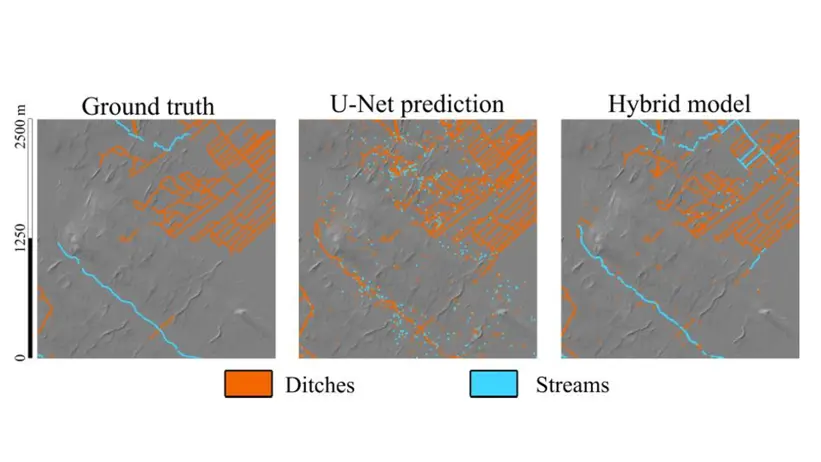
– The AI proved to be very good at identifying ditches. We achieved a correct recall rate of 95% in our training data, and the model found over one million ditches in Sweden. For natural waterways it was more difficult, with a recall of at best 55%, so I believe there is room for improvement there in the future, says Mariana Busarello, PhD student at the Department of Forest Ecology and Management.
Small streams leading to big insights
The new map can reveal more about how our forest landscape is connected. The new data on ditches and streams combined with previously developed maps of elevation and soil moisture unlocks valuable information about how waterways connect to the landscape, which can be extremely useful.
– For example, rewetting is a current challenge where her maps can be used to calculate which areas will be affected after a restoration. Information about waterways can also be used to define buffer zones in forestry and to plan crossings and other measures. These maps will also be part of the development of a new soil-moisture map to be produced in 2026. The soil-moisture map I developed a few years ago lacked any information about ditches and their drainage effects, says William Lidberg, researcher at SLU and Mariana Busarello’s supervisor on the project.
With even higher-resolution data and further development of the AI model, the maps could become even more accurate and detailed in the future, Busarello believes. But at the same time, she wants to warn end users about taking the map’s results at face value.
– When I started my project, I was very dreamy eyed about AI as a tool that could do everything for us. Today I am more sceptical and can see the limitations. We provide a basis for initial decisions, but I advise users not to trust our maps completely and blindly. if it’s a critical area that we’ve mapped that you want to look at, having a field survey on that area will help you avoid the errors, says Busarello.

References:
Busarello, M. (2025). Mapping small water channels using machine learning. (Doctoral thesis 2025:81). Swedish University of Agricultural Sciences.
Mariana Busarello defends her thesis in P-O Bäckströms sal, SLU Umeå on 5 December 2025 at 9.00 AM. Find a Zoom link to the defense here.
Contact
-
Person