
Sampling Design
To enable the inventory of common and less common habitat types within the same framework, a common sampling design has been developed for NILS inventories of alpine areas, grasslands, coastal areas, and deciduous forests. It is a multi-stage design adapted to each inventory.
Background
The mandate to inventory grasslands in general, and in agricultural landscapes specifically, was already part of the NILS baseline inventory from the outset. However, the sample size was too small to provide reliable data beyond the most common habitat types and species. Therefore, a targeted inventory of grasslands was initiated: the NILS Grassland Inventory.
Selection of tracts and field plots for field inventory
In the grassland and deciduous forest inventories, the inventory process consists of two steps: 1) selection of tracts and 2) selection of field plots within each tract (Figure 1). The efficiency of these inventories is partially due to the fact that many areas do not require field visits. By utilizing aerial imagery, it is possible to identify areas that lack the targeted nature types, allowing the exclusion of these areas and sample plots for field inventory. However, they still remain part of the sample. As an example, in 2020, a total of 137,396 sample plots were aerially surveyed across 701 areas. Out of these, 1,763 sample plots distributed among 187 areas were visited in the field.
In the first step, tracts are randomly selected from the sampling frame using a coordinated balanced sampling approach. Subsequently, all plots within the selected tracts are classified into both deciduous forest and grassland classes based on aerial imagery. For the grassland and deciduous forest inventories, the aerial classifications are combined separately to form selection classes.
In the second step, the selection classes are used to randomly choose the plots for field inventory. The selection of plots for field visits in the grassland and deciduous forest inventories is conducted independently of each other.
The Tract
In the grassland and deciduous forest inventories, a tract (1 km × 1 km) consists of 196 circular plots with a radius of 10 m
Inventory in aerial images
In the inventory in aerial images, potential grasslands and deciduous forests within the plots are classified based on a classification scheme. The selection of grassland and deciduous forest types to be inventoried in each sample is determined by their frequency of occurrence in the landscape. Less common habitats are inventoried in larger samples, while more common types are inventoried in smaller samples. The aerial imagery inventory is conducted jointly for both the grassland and deciduous forest inventories, allowing the aerial surveyors to observe each sample plot only once.
Selection of plots for field inventories based on selection classes
The classifications obtained from the inventory in aerial images, are subsequently combined to form selection classes. A random coordinated selection of field plots is then conducted based on these selection classes. The selected plots are subjected to field inventory.
The maximum number of plots chosen to be surveyed in the field per inventory has varied during the first three years. For instance, in the year 2020, a maximum of 10 plots were selected for field visits per tract and inventory, totaling up to 20 field plots per tract for the two inventories combined. The selection was performed at the tract level, and in cases where there were more sample plots than the maximum limit of 10 per tract, the maximum limit per selection class within a tract that were potentially of interest, a subset of the field plots was chosen. The selection of plots for field inventory within an area has been randomized, but weighted in a way that sample plots with higher-priority classes were chosen to a greater extent.
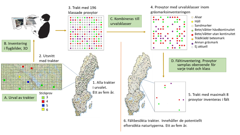
Figure 1. A schematic figure of the steps involved in the sample design and how they are applied in the grassland inventory for the year 2021. In the first step, plots (A) are randomly selected from the sampling framework using a coordinated balanced selection. The sample plots within these plots are classified through remote sensing; in the grassland inventory, this involves aerial imagery inventory (B). The classes derived from remote sensing are then combined to form selection classes. In the second step, a random coordinated selection of sample plots (C) is made for field visits. In the deciduous forest inventory, deciduous forest classes are used instead to classify the sample plots. Figure modified from Ranlund & Hedenås (2023).