Soil Depth
Page reviewed:
10/06/2026
Soil depth describes the thickness of the soil cover. The exact soil depth is difficult to determine and varies greatly. Soil depth is assessed using topography, visible bedrock outcrops, and observations made when digging pits for soil profile description and soil sampling.
Assessment of soil depth
The average depth of the unconsolidated soil layer within the sample plot is assessed by studying the terrain conditions both on the plot and in its immediate surroundings. Soil depth on the sample plot (organic layer + mineral soil) is classified into the following four classes:
| Soil depth class |
Definition and terrain conditions in the immediate surroundings |
| Deep soil | Average soil depth greater than 70 cm. Rock outcrops are absent both on the sample plot and in its immediate surroundings with similar topography. |
| Moderately shallow soil | Average soil depth 20–70 cm. Occasional visible rock outcrops occur. If only one outcrop is present, it must lie wholly or partly within the sample plot. |
| Shallow soil | Average soil depth less than 20 cm. Abundant rock outcrops. At least one visible outcrop within the sample plot. Soil depth may be great in narrow fractures in the bedrock. |
| Variable soil depth | Abrupt changes in soil depth within the sample plot due to wide bedrock fracture zones that are partly exposed at the surface. |
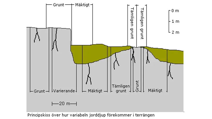
Schematic illustration of how soil depth varies in the terrain. Grunt = Shallow. Varierande = Varying. Mäktigt = Deep. Tämligen grunt = Moderately shallow.
Contact
-
PersonJohan Stendahl, head of department and researcherBiogeochemistry of Forest Soils