Soil Moisture
The soil moisture classes indicate the degree to which the groundwater table affects the forest, the forest soil vegetation, and soil formation. The soil moisture class is determined by the average level of the groundwater table during the growing season.
About Soil Moisture
This level can be assessed in the field primarily based on the topography and the "visible" groundwater table in ditches, wetlands, streams, and any dug pits. Soil moisture is classified into the categories: dry, fresh (mesic), fresh-moist, moist, and wet. Before the 1990s, an additional class was used—"very dry land"—which is now included in the dry land class.
To obtain a measure of soil moisture, one primarily estimates roughly the depth down to the average level of the groundwater table during the growing season (see figure below). The groundwater table is the level at which the water surface stabilizes if you dig a pit in the ground or drive down a perforated pipe. The water pressure at the groundwater table is equal to atmospheric pressure.
In the groundwater zone, all pores are filled with water (the soil is water-saturated) and the water pressure is greater than atmospheric pressure. In the soil water zone (the zone between the groundwater table and the soil surface), there is both water and air in the pores, and the water pressure there is less than atmospheric pressure.
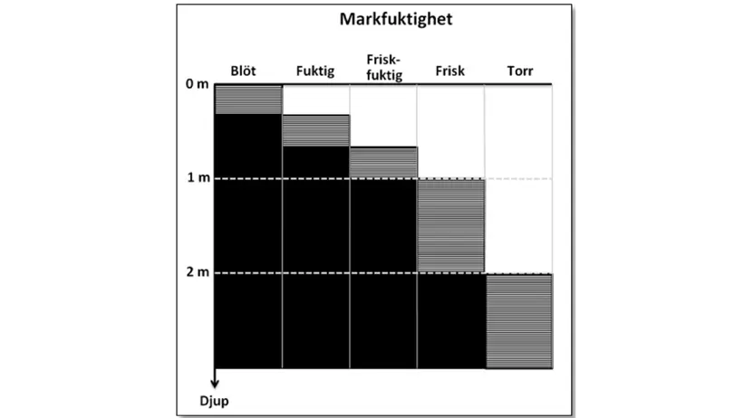
Simplified sketch (from RIS Fältinstruktion 2017). Soil moisture is primarily assessed by roughly estimating the depth down to the average level of the groundwater table during the growing season. This depth varies seasonally and annually; the dashed areas show the interval within which one should expect the average groundwater depth to be for the different moisture classes.
The groundwater table largely follows the slope of the land surface. This is most evident in areas where the groundwater table is close to the soil surface, which is usually the case in Sweden. The deeper the groundwater table lies, the weaker its correlation with the local topography of the land.
The level of the groundwater table is assessed guided by topography, any occurrence of groundwater in depressions, and in any dug pits, and in some cases also supported by the soil profile. The presence of so-called swamp mosses (including peat mosses and common haircap moss) can serve as a guide.
Note that the groundwater level often rises rapidly after clear-cutting, which in some cases may mean that the characteristics mentioned above do not show a clear correlation with the new, actually prevailing soil moisture.
It is always the estimation of the average degree of moisture during the growing season that is decisive for the classification of soil moisture. After heavy rain or snowmelt, the sample plot may temporarily be completely or partially water-covered, especially where the soil texture is fine-grained or where the ground frost still remains. This can lead to assessing the soil as more moist than it actually is.
Very dry land
Main rule:
The groundwater table is not encountered even during deep excavations (>5 meters).
Furthermore, see the definition for dry land.
NOTE! Topographically, the vegetation surface must not be situated so that it receives water from higher terrain sections; i.e., lateral/moving groundwater must be absent.
Dry land
Main rule:
The groundwater table is below 2 metres.
Terrain sections where dry land can be found:
- Flat land on thick glaciofluvial deposits.
- Hills, marked crests, and ridge tops.
- Plateaus and flat, highly elevated terrain sections with bedrock outcrops (i.e., the variable Soil Depth is fairly shallow, shallow, or varying) or with a coarse texture. Coarse texture here means sandy-loamy till/coarse silt or coarser.
Thus, if the soil depth is thick and the texture is silty or finer, the dry land class is only used exceptionally – the fresh land class is then usually assigned, even if the groundwater table is at a depth greater than 2 meters.
If the variable moving groundwater is short or long, the class "dry land" must not be used.
The soil type is often Leptosol, Arenosol, Regosol, or Podzol (then usually with a thin humus layer and thin leached E-horizon/blekjord).
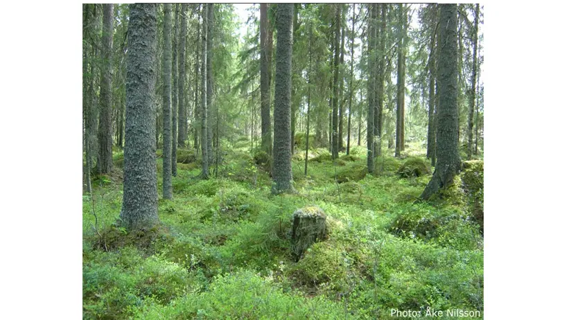
Fresh land
Main rule:
The groundwater table is on average at a depth between 1–2 meters.
Terrain sections where fresh land can be found:
- Flat land and slopes.
No pools of water on the soil surface, neither on the sample plot nor in adjacent areas at the same level as the sample plot. It must be possible to walk dry-shod everywhere on the sample plot, even immediately after rain or shortly after snowmelt.
Sites on fresh (mesic) land may periodically receive water from higher terrain, causing the groundwater table to temporarily rise higher than 1 meter below the soil surface. This can occur during prolonged and heavy rain as well as during snowmelt periods.
If the soil depth is thick and the texture is silty till/fine silt or finer, the fresh (mesic) land class is often used even if the groundwater table is at a depth greater than 2 meters, see above under the dry land class.
All classes in the variable moving groundwater can occur on fresh (mesic) land.
On podzolized soil, the soil type is usually an iron podzol with a fairly thin (4–10 cm) humus layer of the mor type. The ground layer consists mainly of so-called fresh-land mosses (e.g., big red-stem moss, stairstep moss, and broom fork-moss). The leached E-horizon (blekjord) is grayish-white and relatively well-demarcated against the illuvial B-horizon (rostjord), whose color is rusty yellow, rusty red, or brownish rusty red (the darker the color, the moister the soil).
Fresh-Moist land
Main rule:
The groundwater table is on average located at a depth of less than 1 meter.
Terrain sections where fresh-moist land can be found:
- Flat land within relatively low-lying terrain sections.
- The middle and lower parts of longer slopes.
- Flat land adjacent to larger ridges or elevated areas. Particularly within plain areas, even a small drop in elevation relative to the surrounding terrain can result in fresh-moist land.
During summertime, it should be possible to walk dry-shod across the entire sample plot without difficulty, though not after heavy rain or shortly after snowmelt when water may temporarily accumulate in distinct depressions.
Small patches of swamp mosses (common haircap moss, peat moss) occur quite frequently.
The trees quite often grow on so-called root-collars or buttresses (small elevations in the ground surface), which either indicates that the stand has drained the soil to some extent, or that the most viable trees grew on more elevated spots from the very beginning.
On podzolized soil, the soil type is usually an iron-humus podzol or a humus podzol. The humus layer is thicker than on fresh (mesic) land, and the humus form is often a peaty mor.
Moist land
Main rule:
The groundwater table is on average located at a depth of less than 1 meter. It is as a rule visible in marked depressions on the sample plot or in its immediate vicinity.
Terrain sections where moist land can be found:
- Flat land within low-lying terrain sections.
- The lowest part of gently sloping terrain.
- Flat land adjacent to larger ridges or elevated areas.
During summertime, one should be able to walk dry-shod across the sample plot if utilizing hummocks within the moister parts. After prolonged dry periods, a puddle should form around the shoe if stepping in a deeper depression.
Patches of swamp moss are found here and there. It is not uncommon for swamp moss patches to dominate the ground layer.
The trees often grow on root-collars/buttresses. Other signs of waterlogging include graves or channels (often vegetation-free) in the humus layer around boulders, a "hummocky" ground surface, and small pools of water.
The soil type is most often a humus podzol or a hydromorphic/swamp soil.
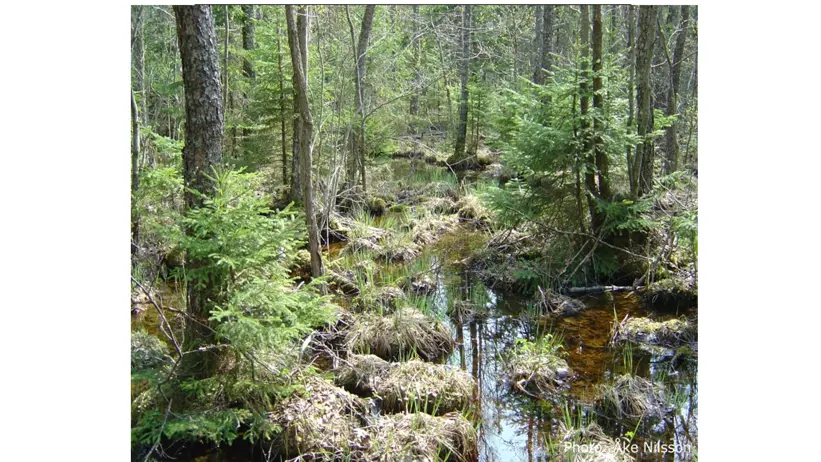
Wet land
Main rule:
The groundwater forms permanent pools of water on the soil surface.
Terrain sections where wet land can be found:
- Sites with very poor drainage conditions.
It is impossible to travel dry-shod. Conifers can only exceptionally form stands.
The soil type is usually a hydromorphic/swamp soil.
Contact
-
PersonJohan Stendahl, head of department and researcherBiogeochemistry of Forest Soils