
About the inventory
The Swedish Forest Soil Inventory surveys soil conditions on approximately 20,000 plots across Sweden, excluding urban areas, farmland, and high mountains. One tenth of the plots are re-visited annually.
Inventory Design
When the Forest Soil Inventory commenced in 1983, it marked the beginning of the integrated soil and forest inventory still ongoing today in collaboration with the Swedish National Forest Inventory (NFI). At the outset, permanent sample plots were established across the country, grouped into so-called tracts. These tracts are square-shaped and consist of eight sample plots, except in the southwesternmost part of Sweden, where they consist of four sample plots. The side lengths of the tracts vary from 300 meters in the southwest to 1200 meters in the north. The distance between tracts also varies across the country, with denser sampling in the south due to the generally more heterogeneous landscape in southern Sweden. Between 1983 and 1987, all sample plots were inventoried, and since then, they have been re-inventoried every ten years.
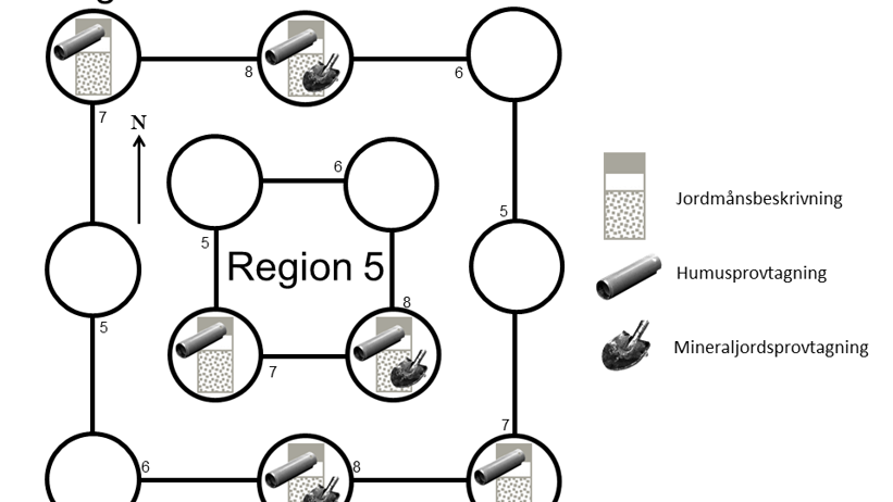
Only half of the sample plots within a tract are used in the soil inventory (see picture below). Soil horizon descriptions and humus sampling are conducted on all these plots, and on half of them, mineral soil sampling is also performed.
From 1993 to 2002, the Forest Soil Inventory also included the inventory of vegetation. Since 2003, the NFI has been responsible for this, although it is still the soil inventory team that conducts the actual fieldwork.
Fieldwork Execution
Soil Horizon Description
The various horizons in the soil profile and soil type are determined based on the international system World Reference Base for Soil Resources (WRB). Some of the variables collected include:
Humus Form
The humus form is primarily determined based on the material composing the humus, its degree of decomposition and structure, the thickness of the humus layer, and the soil's moisture content. Seven different humus forms are distinguished, which can be grouped into the categories of mor, mull, and peat types.
Soil Texture
For sediments and moraines, the texture, which describes the soil's particle size distribution, is assessed visually and through form and rolling tests. It is classified into eight different classes.
Soil Type
Soil type develops in the upper part of the soil through prolonged influence of climate, hydrology, geology, and organisms. Based on the above variables, several others, and the appearance of the soil profile, the soil type is assessed. The soil inventory currently distinguishes eight different soil types based on the WRB system. Between 1993 and 2002, 13 different soil types were distinguished according to the Swedish system.
Soil Sampling
Humus Sampling
The humus sample is taken down to the upper boundary of the mineral soil or to a maximum depth of 30 cm for mor and peat types. For mull types, the sample is taken down to 10 cm depth. The sample is volume-defined using a special humus auger during sampling.
Mineral Soil Sampling: Three to four samples are collected from the interval 0-65 cm below the upper boundary of the mineral soil. If the soil type is registered as peat, mineral soil sampling is omitted, and instead, an additional volume-defined humus sample is collected from the interval 30-50 cm. On the plots where mineral soil samples are taken, DNA samples are also collected from the humus for analysis of fungal DNA presence.
Chemical Analyses
The collected humus and mineral soil samples are sent to our laboratory, where they are dried, weighed, and sieved before a subsample is used for chemical analyses. All samples, both humus and mineral soil, are analyzed for pH and carbon and nitrogen content. Additionally, mineral soil samples are analyzed for exchangeable base cations, exchangeable aluminum, pH measured in KCl, and titratable acidity. Detailed information about the chemical analyses can be found here. The remaining samples are stored in our soil sample archive.
Managing the data
The collected data is compiled and stored in the MiBas database. Some data is available through the tool MarkInfo, which provides maps of the occurrence of various variables across the country and allows for easy calculations. Other data can be requested by contacting us at the Soil Inventory. Our data is available to everyone, but a retrieval fee may apply for larger extractions. Since the Soil Inventory and NFI are conducted on the same sample plots, there is an opportunity to obtain additional data linked to soil variables. The results of the DNA sample collection can be viewed on the page Svampar i Sverige. Also, see the Publication List where we have gathered articles where our data has been used.