Facts:
Project members:
David Parsons, dept. of Agricultural Research for Northern Sweden
Anne-Maj Gustavsson, dept. of Agricultural Research for Northern Sweden
Mats Söderström, dept. of Soil and Environment

Forage crops (predominantly mixed leys) are the most important crops in northern Sweden upon which the dairy production is based. Good farming practices include sufficient and efficient nitrogen (N) fertilisation, enabling high yields. Mapping the within and between fields variability of the biomass, N uptake and potentially also forage quality (digestibility and neutral detergent fibre) would help farmers to optimise their practices.
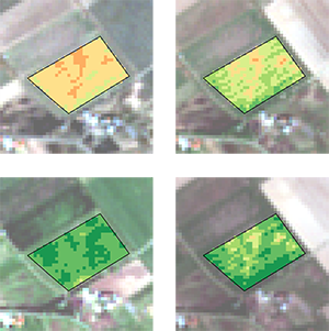
Remote sensing enables monitoring of a field based on the analysis of its spectral signature, and has been successfully used to estimate various traits such as yield of crops or leaf nitrogen contents. The Sentinel-2 constellation provides regional scale images with a high spatial resolution. Due to its high frequency of revisit (approximately 2 days) it is ideal to monitor the dynamics of growth and vigour of crops.
In this project, we will develop regression models to link the spectral data provided by the Sentinel-2 constellation and measurements of biomass, crude protein concentration (and corresponding N uptake) and digestibility. The measurements will be made along the growing season on 5 fields at 4 locations across northern Sweden. The models, if accurate and robust, could be implemented within 3 years into the CropSAT web portal (cropsat.se) to provide a decision support system for farmers in northern Sweden.
Project members:
David Parsons, dept. of Agricultural Research for Northern Sweden
Anne-Maj Gustavsson, dept. of Agricultural Research for Northern Sweden
Mats Söderström, dept. of Soil and Environment