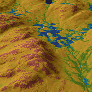
The color shades reflect more the natural variations in the landscape where there are rarely sharp boundaries between different soil moisture classes. The color shades also provide the opportunity to interpret seasonal variations in the map.
The classified SLU Soil moisture map is a high-resolution map that shows soil moisture in three classes; wet - moist, moist - mesic and mesic - dry. If you want to use a classifed map instead of the continuous one, this is the one we recommend. Reclassifying the continuous map does not give as good results.
The soil moisture maps are calculated with artificial intelligence. By combining the information in many different map layers as input into the model and training the model on field data from the national forest inventory, the model learns how topography, climate and soil types control soil moisture in different parts of the country. For those who want to understand the calculations in depth, we refer to the research article.
SLU Soil moisture map was primarily developed for use in forest planning, but can also have other uses. How dry or wet an area is at a certain time depends on how the weather has been. On the SLU Soil Moisture Map, blue and turquoise areas show where the soil can be expected to be wet and moist for most of the year. Green areas show mesic-moist soil where soil moisture can be expected to change more. On such ground you can walk dry footed with shoes in summer, but not after heavy rains or after snowmelt. The green-marked areas risk being connected to nearby watercourses when the runoff is high. In order to protect surface waters, one should therefore be extra careful in both blue and green marked areas on the SLU Soil Moisture Map by, for example, avoiding fertilization, soil preparation and rutting. The SLU soil moisture map also provides information on soil moisture in drier areas. For forestry planning, this information can be useful, for example, when planning roads.
Anyone has the right to download and use the SLU Soil Moisture Map.
The maps are found HERE
For publication, state the source: SLU Soil moisture map, Dept. of Forest Ecology and Management, Swedish University of Agricultural Sciences.
The method-development for the map is described in Ågren, A. M., J. Larson, S. S. Paul, H. Laudon, and W. Lidberg (2021) Use of multiple LIDAR-derived digital terrain indices and machine learning for high-resolution national-scale soil moisture mapping of the Swedish forest landscape. Geoderma, 404, 115280, https://doi.org/10.1016/j.geoderma.2021.115280


